WASHINGTON, July 7 (San Diego News Online) — NOAA forecasters say El Niño conditions are now present in the equatorial Pacific and are expected to strengthen into the Northern Hemisphere winter 2026-27.
The Climate Prediction Center, NOAA’s federal forecasting arm in College Park, Maryland, issued an El Niño Advisory on June 11. The practical takeaway for readers is to follow NOAA’s seasonal updates heading into the November-January period, when the agency says there is a 63% chance of a very strong El Niño.
What is El Niño?
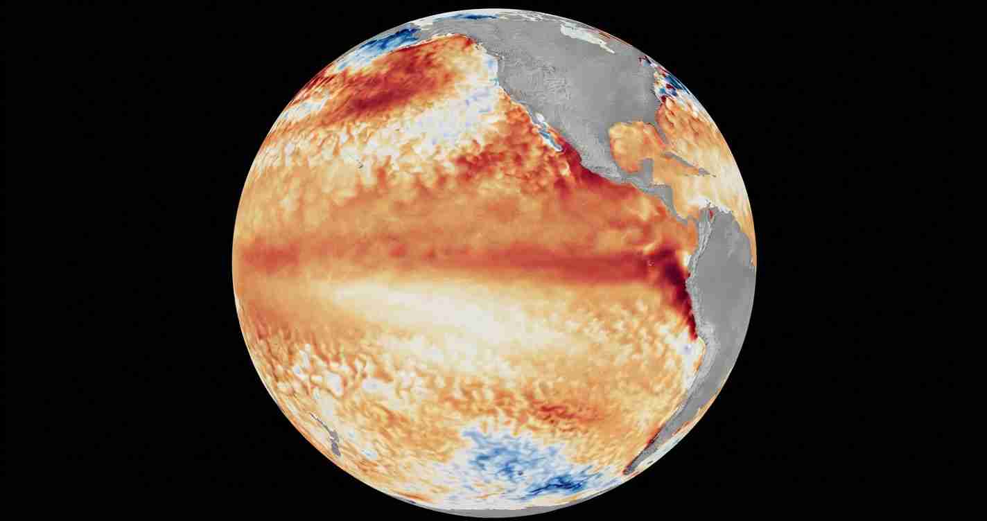
El Niño is the warm phase of ENSO, the natural cycle that tracks changing ocean temperatures and winds in the tropical Pacific. When waters in the central and eastern equatorial Pacific turn warmer than average, the pattern can shift weather far beyond that region.
NOAA says that is what is happening now. In its diagnostic discussion, the Climate Prediction Center said El Niño conditions developed over the previous month, with above-average sea surface temperatures across the central to eastern equatorial Pacific Ocean.
The agency’s latest weekly readings showed the Niño-3.4 index at +0.7°C, the Niño-4 index at +0.7°C and the Niño-1+2 index at +2.1°C. Those are standard measurements NOAA uses to track how warm the Pacific is relative to average.
Why does NOAA think it will get stronger?
The Climate Prediction Center said its North American Multi-Model Ensemble, including NOAA’s NCEP CFSv2 model, points to El Niño intensifying into winter 2026-27. NOAA’s supporting technical bulletin said the warming first showed up in the far eastern equatorial Pacific in early February, then spread farther across the central and eastern Pacific by mid-April.
NOAA also says the odds favor a major event later this year. In its advisory, the Climate Prediction Center said there is a 63% chance of a very strong El Niño during November-January, a level it said could rank among the largest events in the historical record going back to 1950.
How certain is the forecast?
Like all seasonal outlooks, this one is probabilistic, not guaranteed. The forecast is based on ocean conditions and model guidance, and NOAA’s own pages describe the event as strengthening rather than fixed at one final intensity.
An IRI Columbia forecast page also said El Niño conditions are strengthening across the tropical Pacific and gave a weekly Niño-3.4 reading of +1.7°C on June 17, 2026. That underscores the same broad point: the Pacific is warming and forecasters expect the pattern to continue evolving over the coming months.
What does it mean for the U.S.?
This is not a Washington-specific warning or a local emergency bulletin. It is a seasonal climate signal, and its effects are usually felt indirectly through shifts in winter weather patterns.
NOAA’s Ocean Service says an emerging El Niño can increase the chance of high-tide flooding in many U.S. locations. NOAA’s general ENSO explainer says the tropical Pacific’s warm and cool phases can shape weather patterns well outside the ocean itself.
For readers, the key point is timing: NOAA says El Niño is already in place, and the agency expects it to strengthen through the coming Northern Hemisphere winter. The best source to watch is NOAA’s Climate Prediction Center, which will keep updating the outlook as the season approaches.